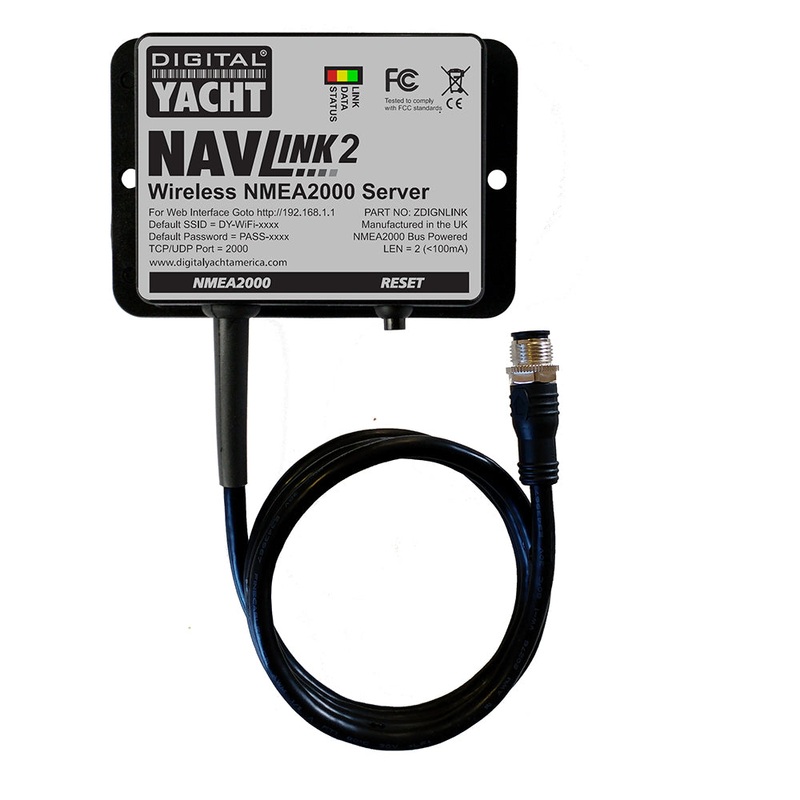
NavLink 2 is an easy to fit NMEA 2000 to Wifi server designed so that NMEA 2000 navigation data can be made available for apps on smartphones, tablets, iPads and PCs. Installation takes seconds as a result of direction connection to the NMEA 2000 back bone and self-powered from the data network.
Once installed, it creates a local WiFi network for devices to connect or can be programmed to join an existing wireless network if one is already installed.This is ideal for devices like the Furuno wireless radar which require operation through their own dedicated network but require NMEA 2000 data integration for charting apps.
NavLink 2 now works with the popular Navionics Boating App forApple iOS and Android. Therefore allowing display of GPS and AIS data on your Navionics charts.
NavLink 2 NMEA to WiFi Gateway
Digital Yacht’s NMEA to WiFi adapter.
NavLink:
NavLink is a low cost app designed for use with an iPhone or iPad. It transforms your iPad into a full function chart plotter with detailed electronic charts and an overlay of your boats position, track and heading.Its purchased through the Apple app store and includes detailed Admiralty UKHO charts covering the whole of the UK & Eire. Additional USA (S57 NOAA), French, Benelux, German and Danish charts can be added via an In-App Purchase.The NOAA S57 charts cover the whole of the US.
Charts can be presented north up or course up and routes and waypoints are created and edited using a simple touch screen interface. Real time navigation shows your current position, track, course, speed, ETA, VMG, bearing and distance to next waypoint. Theres a simple A-B chart ruler too and you can tap on an object such as a buoy or nav-aid and get a pop up data window of its characteristics. Current weather data and local conditions can be downloaded from weather buoys (internet connection required) which is great for last minute local weather before setting off on a voyage. The S57 Admiralty UKHO charts are vector based so data can be layered and enabled / disabled by the user allowing charts to be de-cluttered as appropriate.
Its also designed to work seamlessly with Digital Yachts NMEA to WiFi devices so will integrate with your boats GPS and AIS systems. If AIS data is available, youll see AIS targets overlaid with all their identity information and a heading line as well as alarms for CPA and TCPA.
Utilizing your on board GPS with these wireless servers means you dont need a GPS enabled iPad. Even if your device is GPS enabled, it significantly reduces battery drain when using an external source. It also means your iPad/Phone can be used below deck and generally, the boats GPS is superior for marine based navigation.
NavLink also helps with your watch keeping and lookouts. In HorizonView mode, you can use the camera on the iPhone/iPad to scan the horizon. Youll get an overlay on the camera screen of nav-aids, AIS targets and waypoints which serves as a great visualization aid.
Features:
- Supports Digital Yacht WLN10, iNavHub, NavLink and iAIS products and allows boats NMEA data to be utilised on iPad or iPhone when using this app with these devices
- North up and course up displays
- Real time tracking and track export to Google maps
- AIS overlay when connected to compatible AIS system
- Waypoints and routes with full route editing and planning function
- Position, COG, SOG, VMG, bearing, distance and ETA displays
- Configurable layers: Buoys, lights, depths contours, spot depths, wrecks, traffic zones, anchorages
- HorizonView Overlays nav-aid and targets onto iPad/Phone camera display for easy real time viewing and location
- Automatic free chart updates included for 1 year
- Weather buoy data
- A-B chart ruler for quick and easy bearing and distance measurement
- All UK & Ireland charts are included in the price
- Additional French, Benelux, German and Danish charts available for In-App purchase
Tide and sunrise/set displays
- US version also available (NavLink US)
NavLink 2 NMEA to WiFi gateway Digital Yachts NMEA to WiFi adapter. NavLink: NavLink is a low-cost application designed for iPhone or iPad. It turns your iPad into a complete… !!!!—-
PRODUCT ID: 76401
SKU: NVN-76401
CSKU: CWR-76401
REWRITE: 87512-digital-yacht-navlink-2-nmea-to-wifi
MPN: ZDIGNLINK
UPC: 081159830915
ASIN:
WSKU: DIYZDIGNLINK
SSKU:
KSKU:
GSKU: ZDIGNLINK
MSKU:
LSKU:
NAME: Digital Yacht NavLink 2 NMEA to WiFi Gateway
NAME_EX: DIGITAL YACHT NAVLINK 2 NMEA TO WIFI GATEWAY
PTITLE: Digital Yacht NavLink 2 NMEA to WiFi Gateway
TYPE: Marine Navigation & Instruments | NMEA Cables & Sensors
VENDOR: Digital Yacht
Google Category: ELECTRONICS > MARINE ELECTRONICS > MARINE CHARTPLOTTERS & GPS
Amazon Category:
Amazon Title:
Google Title: Digital Yacht Navlink 2 Nmea To Wifi Gateway by Hodges Marine
Amazon Category:
Gtags:
GSpecs:
 Sale!
Sale! 


Reviews
There are no reviews yet.