Garmin GPSMAP 79sc – Marine Handheld Preloaded With BlueChart g3 Coastal Charts – Remanufactured
Model: 010-N2635-02
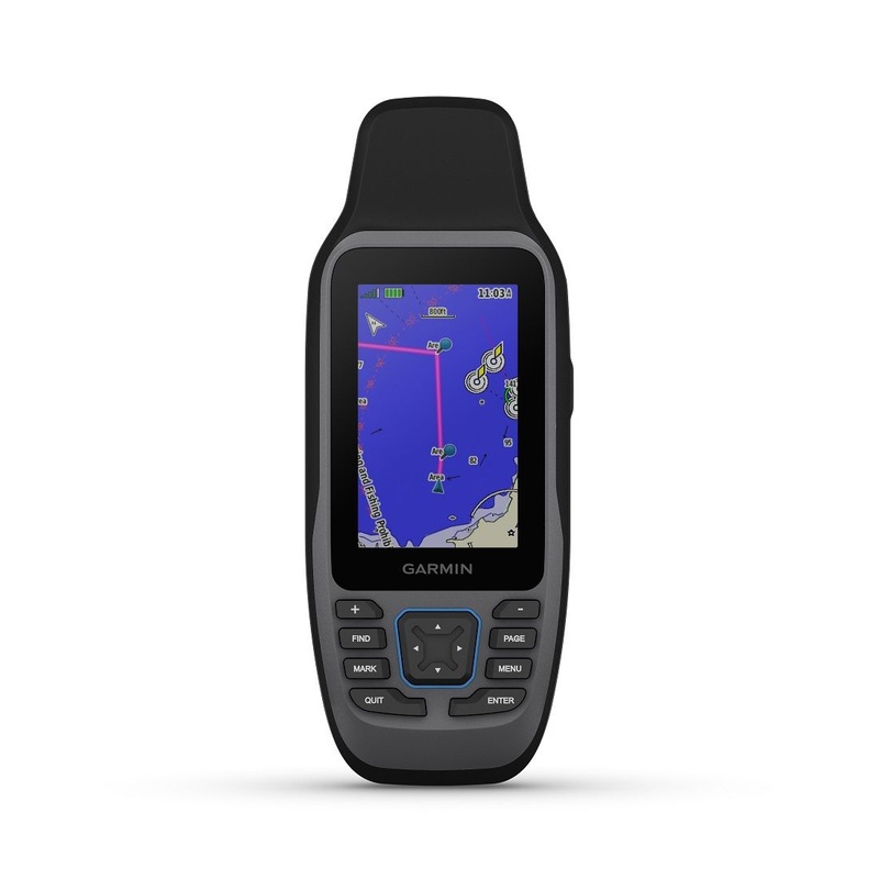
- Rugged, floating, water-resistant (IPX6 unit level only) handheld GPS with a high-resolution color display and scratch-resistant, fogproof glass
- Increased memory to save and track 10,000 waypoints, 250 routes and 300 fit activities
- Supports multiple satellite constellations (GPS, GLONASS, Beidou, Galileo, QZSS and SBAS) for reliable tracking around the world
- Includes worldwide basemap
- Built-in 3-axis tilt-compensated electronic compass shows heading while standing still
- Barometric altimeter tracks changes in pressure to pinpoint your precise altitude
- Battery life: up to 20 hours in GPS mode
Cast off confidently with the GPSMAP 79s marine GPS handheld. This rugged, floating handheld features a sunlight-readable, high-resolution color display that is fogproof and scratch-resistant. You get access to a range of satellite constellations, so you get more reliable, accurate tracking around the world. Navigate wherever your adventures take you with the worldwide basemap. With more memory than previous models, you can save and track 10,000 waypoints and 250 routes. Keep your bearings with the built-in compass.
This handheld is water-resistant (IPX7) with a high-resolution color display you can read in the sun. The glass is even scratch-resistant and fogproof.
If rough waters come and the handheld goes overboard, dont worry. This device floats.
User-replaceable AA batteries (not included) provide up to 19 hours of battery life in GPS tracking mode.
With support for multiple satellite constellations such as GPS, GLONASS, Beidou, Galileo, QZSS and SBAS youll get accurate, reliable tracking and positioning around the world.
More memory than previous models means you can save and track 10,000 waypoints, 250 routes and 300 fitness activity files.
The 3-axis tilt-compensated electronic compass shows your heading even while the boat is standing still.
Preloaded BlueChart g3 coastal charts (GPSMAP 79sc only) give you leading-edge coverage, clarity and detail with integrated Garmin and Navionics data.
Specifications
| General |
| PHYSICAL DIMENSIONS |
2.67” x 6.85” x 1.67” (6.77 x 17.40 x 4.23 cm) |
| DISPLAY SIZE |
1.5″”W x 2.5″”H (3.8 x 6.3 cm); 3″” diag (7.6 cm) |
| DISPLAY RESOLUTION |
240 x 400 pixels |
| DISPLAY TYPE |
transflective, 65K color TFT |
| WEIGHT |
9.95 oz (282g) with batteries |
| BATTERY TYPE |
2 AA batteries (not included); NiMH or Lithium recommended |
| BATTERY LIFE |
up to 19 hours |
| WATER RATING |
IPX7 |
| MIL-STD-810 |
yes (thermal, shock, water); bare unit only |
| HIGH-SENSITIVITY RECEIVER |
Yes |
| INTERFACE |
high speed microUSB and NMEA 0183 compatible |
| MEMORY/HISTORY |
8 GB (user space varies based on included mapping on sc version) |
| Maps & Memory |
| PRELOADED MAPS |
BlueChart g3 Coastal Charts |
| ABILITY TO ADD MAPS |
Yes |
| Basemap |
Yes |
| AUTOMATIC ROUTING (TURN BY TURN ROUTING ON ROADS) FOR OUTDOOR ACTIVITIES |
Yes (with optional mapping for detailed roads) |
| MAP SEGMENTS |
15000 |
| INCLUDES DETAILED HYDROGRAPHIC FEATURES (COASTLINES, LAKE/RIVER SHORELINES, WETLANDS AND PERENNIAL AND SEASONAL STREAMS) |
Yes (downloadable from Garmin Express) |
| INCLUDES SEARCHABLE POINTS OF INTERESTS (PARKS, CAMPGROUNDS, SCENIC LOOKOUTS AND PICNIC SITES) |
Yes (downloadable from Garmin Express) |
| DISPLAYS NATIONAL, STATE AND LOCAL PARKS, FORESTS, AND WILDERNESS AREAS |
Yes (downloadable from Garmin Express) |
| EXTERNAL MEMORY STORAGE |
yes (32 GB max microSD card, not included) |
| WAYPOINTS/FAVORITES/LOCATIONS |
10000 |
| TRACKS |
250 |
| TRACK LOG |
20,000 points, 250 saved gpx tracks, 300 saved fit activities |
| 20,000 points, 250 saved gpx tracks, 300 saved fit activities |
250, 250 points per route; 50 points auto routing |
| RINEX LOGGING |
Yes |
| Sensors |
| GPS |
Yes |
| GLONASS |
Yess |
| Galileo |
Yes |
| QZSS |
Yes |
| Compass |
Yes (tilt-compensated 3-axis) |
| GPS COMPASS (WHILE MOVING) |
Yes |
| Outdoor Recreation |
| POINT-TO-POINT NAVIGATION |
Yes |
| AREA CALCULATION |
Yes |
| HUNT/FISH CALENDAR |
Yes |
| GEOCACHING-FRIENDLY |
Yes (Paperless) |
| CUSTOM MAPS COMPATIBLE |
Yes |
| PICTURE VIEWER |
Yes |
What’s in the Box:
- GPSMAP 79s – Remanufactured
- Lanyard
- USB Cable
- Documentation
!!!!—-
PRODUCT ID: 1003522
SKU: NVN-1003522
CSKU: CWR-1003522
REWRITE: 1014633-garmin-gpsmap79sc-reman-with-sensors-built-in-bluechart
MPN: 010-N2635-02
UPC:
ASIN:
WSKU: GAR010N263502
SSKU:
KSKU:
GSKU:
MSKU:
LSKU:
NAME: Garmin GPSMAP79SC Reman With Sensors Built-in BlueChart G3 Coastal
NAME_EX:
PTITLE: Garmin GPSMAP79SC Reman With Sensors Built-in BlueChart G3 Coastal
TYPE: Marine Navigation & Instruments | GPS – Chartplotters
VENDOR: Garmin
Google Category: ELECTRONICS > MARINE ELECTRONICS > MARINE CHARTPLOTTERS & GPS
Amazon Category:
Amazon Title:
Google Title:
Amazon Category:
Gtags:
GSpecs:
 Sale!
Sale! 

Reviews
There are no reviews yet.